Directions to NIACC
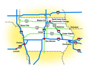
NIACC is situated on a 500-acre countryside campus on the east edge of Mason City, Iowa. We’re located two hours south of Minneapolis/ St. Paul and two hours north of Des Moines, with easy access to the Avenue of the Saints and Interstate 35. The resort community of Clear Lake is also nearby, just a few miles west of Mason City.
-Click the title to view directions.
Through Town…
Take Interstate 35 to Exit 194
You’ll be traveling East on Highway 122
This highway takes you straight to NIACC
(approximately 12 miles from the Interstate)
NIACC will be on your left
(You’re going to feel like you’re heading out of town,
but don’t turn around. You can’t miss the sign!)
Skirting Town…
Take Interstate 35 to Exit 190
You’ll be traveling East on Highway 18
Turn off at Exit 190
(yes, it’s the same number as before)
Go North on county road S56
(California Avenue) until you reach the stop sign
Turn left onto Highway 122 and go approximately
one-quarter mile, NIACC will be on your right
Take Highway 18 West
Turn off at Exit 190
Go North on county road S56
(California Avenue) until you reach the stop sign
Turn left onto Highway 122 and go
approximately one-quarter mile
NIACC will be on your right
Take Highway 18 East
(it will change to Highway 122 at Clear Lake)
This highway takes you straight to NIACC
(approximately 12 miles from Clear Lake)
NIACC will be on your left
(You’re going to feel like you’re heading out of town, but don’t turn around. You can’t miss the sign!)
Mason City is served by Mesaba Airlines, a Northwest Airlines link from Minneapolis, MN. The other closest airports are Minneapolis/St. Paul International Airport, Rochester, MN, Des Moines and Waterloo, IA.
Mason City is served by Jefferson Bus Lines. A bus station is located at the Mason City Municipal Airport.

